Inspired by others, and my goal of getting a golden WiGLE badge, I went wardriving for my birthday. I was hoping for 50k, and I ended up with just over 61k. I'm less than 80k away from my goal!
But how do you pick a place to wardrive, and how do you actually do it? The easiest way is to download WiGLE on an android phone, get some transportation, and be set on your way. But if you want more detail or some tips, keep reading.
Avon Lady Method:
- Find a city within reasonable distance of travel
- Examine the results for the past few years of the area; do not use the overall coverage of all time.
- Verify if the city is desirable for wardriving
- Little coverage in the past few years
- Most residential areas are not covered
- Use maps to search and define high density residential areas (i.e. apartments, town homes).
- Create an order that allows for little overlapping and in a convenient driving pattern.
- Use landmarks around the city to define the internal roads
- Wardrive
- Profit ("internet points")
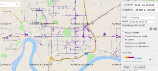
Evansville, IN
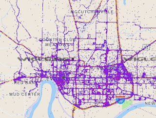
I picked this location because of its relative distance to me, and the fact it looked like stumblers haven't touched the area recently. Below shows a map of Evansville 2020 - 2023. So for the last two years this is the only progress than Evansville has made. It looks like most of the concentration is on major roads, with only a few residential areas defined.
Residential areas have multiple wifi devices per dwelling, so apartment complexes have a high density of wifi and bluetooth. Those places aren't well defined by the map, so I assumed I would get a lot of results there.
But you can't just drive around and magically get yourself to where the map is bare. It takes some planning. I call this the Avon Lady Method. Avon ladies may blanket a neighborhood with their brochures, selecting high density areas to get the most clients. Shoutout to my mom.
I pulled up Evansville on Google Maps and got to work. Printing out a couple of paper maps of Evansville, I matched up the roads to the results on Google Maps searching for apartments. I plotted some areas on the paper map to see where I was going to drive. I then wrote the order of the apartments to the path that I wanted.
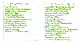
The numbers at the top reference a part of the map. They aren't really important. After laying out the order of the results, I broke the lists up into different quadrants of the city. Then we went down the list crossing them off as we blanketed the residentially areas.
This would get us isolated parts of the map, but what about the center? What about the business part of the city? Using Google Maps again, I zoomed out and picked the businesses than would get the pattern I wanted and put those in order too. I called these landmarks.
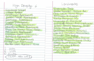
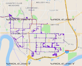
The result got me the same amount of networks as all of 2021 and 2021 in Evansville. Removing all results by others, here's what the wardrive worked out to:
Comments
Post a Comment